

Rural Homesite Questions to Ask Before Building a Custom Home in Spicewood
📌 Key Takeaways
A rural parcel works only when verified access, usable space, infrastructure, and site conditions support your full building plan.
Define Your Full Plan: The author recommends listing your home, outdoor spaces, future additions, and upkeep limits before comparing properties.
Question Usable Acreage: Listing acreage can overstate usable space once setbacks, easements, slopes, drainage, wastewater, and construction needs overlap.
Verify Every System: The author recommends confirming legal access, utilities, and wastewater options through current records and responsible providers.
Trust Qualified Assessments: Surface clues cannot confirm drainage, soil, rock, flood risk, or grading needs; qualified experts must assess them.
Assign Every Unknown: Each unresolved question needs a named expert, clear evidence, and acceptable risk level before purchase or design.
Great views never replace parcel-specific proof.
Spicewood land buyers will avoid costly surprises by using the rural homesite questions and verification steps below.
~ ~ ~ ~ ~ ~ ~ ~ ~ ~ ~ ~ ~ ~ ~ ~ ~ ~
A rural listing near Spicewood can offer the acreage, privacy, and views you've been imagining—but acreage is not the same as a workable homesite. The parcel that looks perfect on a Saturday afternoon may carry access limitations, infrastructure gaps, or restrictions that reshape what you can build and what the project will cost.
Before you make an offer, you need a short set of questions and a clear picture of who can actually answer each one. Some answers come from the seller or listing. Others require a builder, surveyor, engineer, utility provider, title professional, or governing authority. Mixing up those roles is where surprises begin.
The framework below covers lifestyle fit, usable area, access, infrastructure, physical conditions, and verification responsibility. Use it during a property tour to separate what you can observe from what you need confirmed.
Start With the Life and Home the Property Must Support
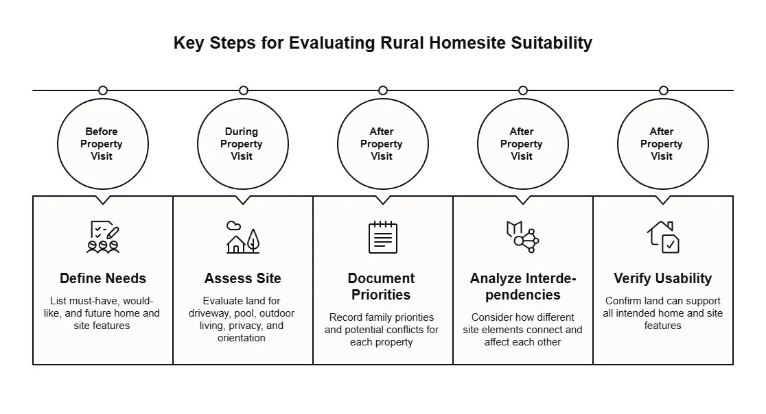
Before evaluating any parcel, define what the land needs to hold. A five-acre property that cannot accommodate your driveway approach, pool orientation, and future workshop is not five usable acres—it is an expensive compromise.
Must have: Approximate home size and layout, garage type and arrival sequence, primary outdoor living areas, privacy from neighbors or roads, and orientation preferences for light or views.
Would like: Pool and surrounding hardscape, covered outdoor kitchen, garden or orchard area, dedicated guest or equipment parking.
Future option: Detached guest house or casita, workshop or studio, additional storage, or a second driveway entrance.
Include future options now, even if you do not plan to build them immediately. Evaluating a property only against the home's first phase is how buyers discover two years later that the lot cannot support the addition they always intended.
Add daily upkeep to the list. Decide how much landscaping, driveway maintenance, acreage management, or slope navigation you are prepared to handle long-term, and whether the layout should reduce steps, travel distance, or grade changes between frequently used areas.
Write each item down before you visit another property. If two family members have different priorities, record both—a parcel that fits one program but not the other will surface that conflict after money has been spent on design.
Then consider how the elements connect. Garage orientation can change the home's approach, turning space, and driveway route. A pool needs more than its own footprint—it affects circulation, privacy screening, and outdoor living adjacency. A workshop or guest space may need separate access and supporting systems. These interdependencies mean that moving one piece on the site plan often moves several others.
This exercise is about knowing, before you fall in love with a view, whether the land has room for the life you intend to build. For a deeper look at how home footprint, pool, and driveway compete for space, see Can Your Lot Hold the Home, Pool, and Driveway You Want?
How Much of the Acreage Is Practically Usable?
Total acreage on a listing tells you the boundary—not how much of that area can support a home, driveway, outdoor features, wastewater system, and construction staging all at the same time. Usable site area means the portions of a property that may practically accommodate the intended layout after known physical, legal, and planning constraints are considered. Treat it as a question to investigate, not a confirmed label.
Several factors reduce usable space, and they stack. Easements—rights granted to others to use part of the property—may cross in locations that restrict building. Setbacks imposed by the governing jurisdiction or recorded restrictions push the buildable envelope inward from every boundary. Slopes, drainage paths, rock outcrops, and existing trees or structures occupy area and influence placement.
Now overlay your program: home footprint, garage and turnaround, pool and grade work, wastewater system area, outdoor structures, and a staging zone for construction vehicles, equipment, and materials. On an irregularly shaped parcel, those elements compete for the same portion of the land.
Imagine a buyer who wants a single-story home with a three-car garage, a pool, and a detached workshop. On a long, narrow parcel with a drainage swale through the center, the driveway, home, pool, and workshop may all need one side of the property while the wastewater system needs the other. That is a planning conversation, not a crisis—but it needs to happen before the offer.
A current survey is essential, but a survey alone does not answer every question about what will fit. It can establish boundaries and show certain features within its scope, yet it does not resolve utility, wastewater, engineering, title, or regulatory questions. Those require applicable official records, title materials, and qualified professional input. To understand how boundary geometries influence what you can actually build, review these lot-shape questions that affect design options.
What Will Legal and Practical Access Require?
Access has two sides. The first is legal: does the property have documented, recorded access—an easement, a dedicated right-of-way, or direct frontage on a public road? The second is physical: can the route support daily traffic, delivery vehicles, emergency response, and the heavy equipment needed during construction? A visible dirt track does not prove legal access, and a recorded easement does not guarantee the route is graded, drained, or wide enough for a concrete truck.
For the legal side, start with current title materials and recorded documents. Have a title resource and qualified legal professional address rights, restrictions, and obligations within their roles rather than relying on a seller's description alone.
For the physical side, examine the possible entrance and route to the home. Grade, sight distance, surface condition, drainage, width, turnaround space, gate placement, and emergency vehicle access all matter—and some may require input from a builder, engineer, or the applicable authority. Test garage orientation as part of this route: a side-entry, front-facing, or courtyard concept may change the approach and shift the home's position on the site.
Where the driveway enters the property affects more than circulation. It influences guest arrival, privacy from the road, and how service vehicles approach. If the entrance sits at the bottom of a slope, water management along the drive becomes a design factor. If a gate is planned, queuing distance between the gate and the road matters for safety and convenience. Maintenance expectations should also match what you are willing to manage over the long term—a steep gravel drive requires different upkeep than a paved, gently graded approach.
Construction access deserves its own question. Concrete trucks, excavation equipment, and material deliveries need a route that may be wider or stronger than the finished driveway. If the only access crosses a shared easement, confirm the terms before construction planning begins.
To explore how these approach routes dictate the rest of the site plan, see How Driveway Access Shapes Early Home Planning.
Which Utilities and Site Systems Are Actually Available?
"Utilities available" on a listing is a starting point, not a confirmation. For each system your home will need, follow a three-step sequence: ask the listing side for its basis, confirm with the relevant provider or authority for the exact parcel, and then discuss design implications with your builder.
Water. Determine whether the parcel is served by a provider or will require a private well. If a provider exists, request written confirmation of availability, capacity, and connection requirements. If a well is needed, permitting, drilling, testing, and equipment each carry their own timeline. Because groundwater depths and yields vary drastically in the Texas Hill Country, relying on a neighboring property's well performance is not a guarantee of your own.
Wastewater. First ask whether a sewer connection is possible—do not assume an onsite system is required. If the parcel does need an onsite wastewater system, approval depends on soil conditions, available area, setback compliance, and the applicable authority's current requirements. The system's location can affect where the home sits, so this is a placement question as much as a regulatory one. Confirm the process with the authority governing onsite wastewater for the specific parcel.
Electricity. Ask the provider whether power reaches the property boundary or requires an extension. Measure extension questions in actual route distance rather than accepting "nearby" as an answer. Extension distance, easements for lines, transformer placement, and associated costs should come directly from the provider.
Communications. Internet and phone service vary significantly between rural parcels. Contact the potential provider to confirm availability at the exact location.
For every system, request current written confirmation from the identified provider. A listing statement or area-wide assumption is not parcel-specific evidence. After documenting the underlying information, ask your builder how system locations, extension work, and installation requirements could affect layout, access, sequencing, and preliminary budget planning.
What Might Terrain, Drainage, Rock, or Vegetation Change?
A walk-through can reveal questions, but it cannot diagnose the site. Record observations for the appropriate professional rather than converting appearance into a conclusion.
Grade and orientation. Slope influences foundation type, driveway design, drainage management, and outdoor living placement. Note the direction the slope faces—orientation affects sun exposure, cooling loads, and which rooms receive morning or afternoon light.
Drainage. Walk the property after a rain if you can. Visible water paths, ponding, erosion, or silt deposits are observations, not conclusions—actual drainage behavior, flood exposure, and regulatory implications require official mapping and qualified professional assessment for the specific parcel.
Rock and soil. Subsurface conditions affect excavation, foundation design, wastewater feasibility, and utility trenching. What looks like solid ground may sit on shallow rock or soil that requires engineering. In the Spicewood and greater Texas Hill Country area, encountering shallow limestone or caliche is common, which can significantly increase excavation costs for a pool, utility trenching, or the home's foundation. These conditions are not visible from the surface and typically require professional evaluation.
Vegetation. Mature trees add character but occupy space and may be subject to removal restrictions. A tree grouping that defines the property's appeal might conflict with preferred home placement, driveway alignment, or the wastewater area.
Physical priorities can create trade-offs that cascade through the site plan. Consider a buyer who wants to preserve a cluster of oaks near the center of a parcel. That preference may shift the home footprint, change driveway geometry, or push the pool to a different side of the site. On another property, preserving a favored view corridor might alter the garage approach and outdoor layout entirely. These are planning trade-offs, not problems—as long as they are recognized before design begins.
Before checking rules on any of these conditions, determine the exact county, local authority, HOA/POA, or other jurisdiction that governs the parcel and each issue. Parcel-specific verification means confirming an answer through current records, the responsible provider or authority, and qualified professional input appropriate to that question.
Who Should Answer Each Question Before You Rely on It?
Assign every open question to the right source—and resist treating a preliminary answer as proof. A listing, seller statement, visual observation, or builder discussion may identify a likely issue or possible direction, but confirm the underlying legal, technical, utility, and approval facts with current records and the appropriate providers, professionals, and authorities.
| Question Area | Why It Matters | Preliminary Input | Confirmation Needed |
|---|---|---|---|
| Desired home, outdoor spaces, and future structures | Sets fit criteria, including maintenance and acceptable unknowns | Buyer's own program and priorities | Builder or designer to test fit against site |
| Boundaries, easements, and setbacks | Identifies land that may affect layout or use | Listing materials and older survey | Current survey, recorded documents, title review, and qualified legal input as needed |
| Legal access and recorded rights | Determines whether you can reach and use the property as planned | Listing or seller disclosure | Title materials, recorded easements, and qualified legal review |
| Driveway design and construction access | Connects entry point, garage orientation, circulation, and logistics | Builder's early site discussion | Appropriate engineer or authority input where grade, drainage, or permits apply |
| Water, electricity, and communications | Affects equipment locations, responsibilities, timing, and planning | Listing or area knowledge | Direct written confirmation from each provider for the exact parcel |
| Sewer connection or onsite wastewater | Either path can influence home placement and approvals | Seller, builder, or qualified professional | Parcel-specific professional evaluation and governing-authority confirmation |
| Drainage, flood exposure, and grading | Physical conditions can change design and construction choices | Visual observations during a walk | Current official mapping or records plus qualified analysis suited to the issue |
| Soil, rock, and subsurface conditions | Subsurface realities affect foundation, excavation, and system feasibility | Surface appearance | Geotechnical or other appropriate professional evaluation |
| Deed restrictions, HOA/POA rules, and permits | Rules and recorded obligations may limit or condition the plan | Listing summary or seller | Recorded governing documents and the applicable authority |
| Cost and design implications | Converts confirmed information into planning choices | Early builder discussion | Builder's estimate after verified site inputs are available |
A builder's early visit to the property can help connect your vision to the site's realities. Riverbend Homes, for example, describes its first step as a property-based Discovery Meeting where the client's vision, site feasibility, and infrastructure implications for budget and design are discussed. That kind of conversation is valuable—but it does not replace the surveyor, engineer, title professional, utility provider, onsite-wastewater authority, or governing jurisdiction. Each has a distinct role, and the checklist works only when every row has an owner.
For builder-specific questions to prepare before making an offer, see What Spicewood Land Buyers Should Ask a Custom Home Builder Before Making an Offer.
Turn Property Excitement Into a Verification Plan
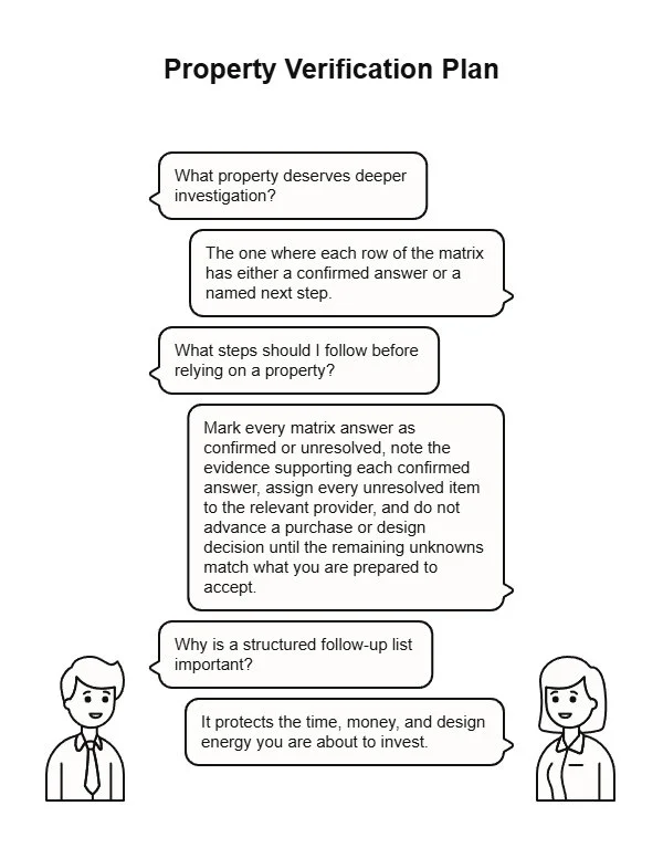
Rural land near Spicewood rewards buyers who ask better questions early. The property that deserves deeper investigation is the one where each row of the matrix above has either a confirmed answer or a named next step—not the one that simply felt right on a sunny afternoon.
Save this framework and follow these steps before relying on any property as a fit:
Mark every matrix answer as confirmed or unresolved.
Note the evidence supporting each confirmed answer.
Assign every unresolved item to the relevant provider, professional, authority, title resource, HOA/POA, or builder.
Do not advance a purchase or design decision until the remaining unknowns match what you are prepared to accept.
A structured follow-up list protects the time, money, and design energy you are about to invest.
Frequently Asked Questions
When should a custom home builder see a rural property?
Involve a builder while unresolved site questions can still inform the purchase decision and before the design becomes fixed. A builder can help identify how your intended home, access, and outdoor spaces relate to what the site can support—ideally before you commit to an offer or begin design. That conversation does not replace a current survey, title review, utility confirmation, onsite-wastewater evaluation, or other specialist and authority checks the parcel may require.
Who verifies whether a rural homesite has legal access and usable boundaries?
Legal access depends on recorded documents—easements, rights-of-way, or public road frontage—reviewed through current title materials and, where needed, qualified legal counsel. Usable boundaries require a current survey combined with recorded restrictions and applicable setbacks from the governing authority. A visual walk or listing map is a starting point, not a substitute.
How can I confirm utilities before buying land near Spicewood?
Identify the potential provider for each system—water, electricity, communications—and request direct written confirmation of availability, connection requirements, and any extension or capacity limitations for the exact parcel. Verify sewer, onsite wastewater, and water questions separately with the appropriate authority or professional for the property's location. Do not rely on a listing statement or area-wide assumption; conditions vary from one parcel to the next.
Disclaimer: This article is for general educational purposes only and does not constitute legal, surveying, engineering, environmental, financial, real-estate, or code-compliance advice. Conditions, requirements, and approvals vary by property and jurisdiction. Verify information for the specific parcel with the appropriate qualified professionals, service providers, title resources, HOA/POA, and governing authorities before making a purchase or design decision.
Our Editorial Process
Riverbend Homes content is created to help Texas Hill Country homeowners make clearer, calmer custom-home decisions. The editorial process begins with Riverbend's documented building process, local experience, client-facing materials, and verified internal resources. Drafts are reviewed for practical accuracy, plain-language usefulness, local relevance, and alignment with Riverbend Homes' site-first approach before publication.
About the Riverbend Homes Insights Team
The Riverbend Homes Insights Team is our dedicated engine for synthesizing complex topics into clear, helpful guides. While our content is thoroughly reviewed for clarity and accuracy, it is for informational purposes and should not replace professional advice.